
Walking across suspension bridges in Ontario offers the perfect mix of excitement, wonder and fear, which is tough to find anywhere else. For some, like my husband, you’ll find him white knuckling the entrance poles. Sure, being 30 feet above a gorge like the Ranney Gorge Suspension Bridge can be intimidating, even though it can hold up to 75,000 pounds! Though I promise you won’t need to test that limit!
Whether you’re after breathtaking photos or love the gentle sway beneath your feet, Ontario suspension bridges offer some of the most spectacular views in the province. I’ve explored several hanging bridges across Ontario and can say fall is the most magical season of all! It makes for stunning photos when you’re surrounded by vibrant autumn foliage. Beyond just stunning photos, many of these structures are part of larger trail systems, like the Ranney Gorge bridge, which is part of The Great Trail, the world’s longest hiking trail!
In this guide, I’ll walk you through 12 unforgettable suspension bridges that should be on your 2026 Ontario adventure list. From engineering wonders to hidden gems, these cool bridges offer more than just a way to get from one side to another – they’re destinations in their own right.
Spread the Love
Disclosure: Posts may contain affiliate links. Purchases made through our links result in a small commission to us at no charge to you. We only recommend products that meet our brand standards based on testing and first hand use by our authors.
Ranney Gorge Suspension Bridge in Campbellford
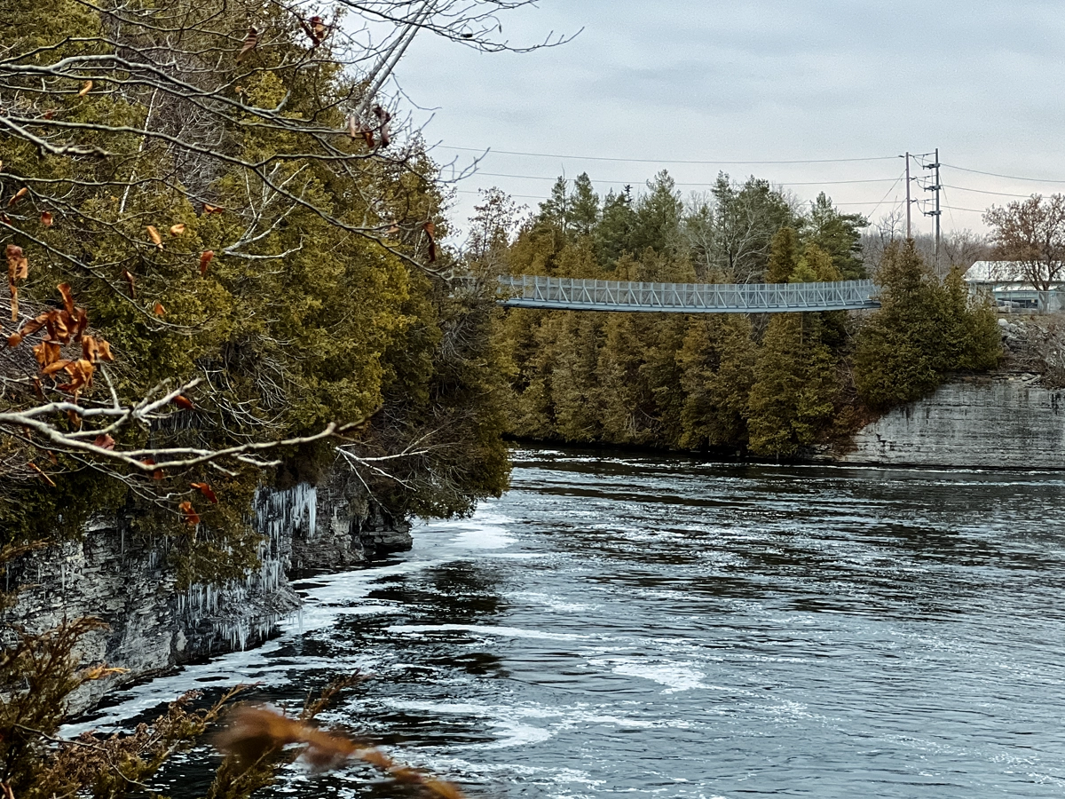
The Ranney Gorge Suspension Bridge is one of Ontario’s most impressive pedestrian bridges, giving visitors a unique chance to experience both architectural beauty and natural magnificence at the same time.
Location of the Ranney Gorge Suspension Bridge
Located in Northumberland County at the southern edge of Campbellford, this incredible suspension bridge is about 170 km northeast of Toronto and 250 km southwest of Ottawa. The bridge’s precise coordinates are 44.2926 N, 77.8011 W, making it easy to locate with GPS on your next Ontario road trip.
Visitors have two access points to choose from:
- Access Point #1: Through Ferris Provincial Park at 474 County Road 8, Campbellford
- Access Point #2: Adjacent to Locks 11/12 at 15 Trent Drive, Campbellford (recommended for winter visits or tight budgets)
A lesser-known entry point with limited parking is available at 199 Saskatoon Avenue, offering a short 1 km forested hike leading to the bridge.
Notable Features of the Ranney Gorge Suspension Bridge
Constructed as a training initiative by the engineers of 8 Wing CFB Trenton (Canadian Armed Forces), this engineering wonder was opened to the public in 2004. The bridge is made from 55,000 pounds of steel and can hold an impressive total weight of 75,000 pounds.
The structure stretches 92 meters (301 feet) from one end to the other, with abutments that reach 98 meters (321.5 feet). Suspended 30-35 feet above the water (depending on the water levels), the bridge has a natural sag or deflection of 2.4 meters (7.9 feet) from the abutments to the center.
What Can Be Seen From the Ranney Gorge Suspension Bridge
Visitors from the bridge can take in a stunning 360-degree view of the gorge, Ranney Falls to the north, and the Trent River below. The open metalwork design enhances these sweeping views, but not for all. My pup refuses to cross and will insist on being carried across – thank goodness he’s small.
The cool part is that the bridge acts as a gateway to the trail system within Ferris Provincial Park, including the Ranney Falls Trail. Most trails are easy with the exception of the river trail, which is rugged and can get slippery.
Ranney Gorge Suspension Bridge Parking & Tickets
Getting to the bridge is completely free when you enter from the west side via Trent Drive (15 Trent Drive) near Locks 11 and 12. Free parking in this small lot is open all year.
However, if you enter through Ferris Provincial Park (open May-October), standard provincial park fees do apply. There’s also a small dead-end parking lot on Saskatoon Avenue that offers another free option, though spaces are very limited.
Because this bridge is open daily throughout the year, it allows you to witness the changing seasons and enjoy hiking or cycling in the park. It’s a unique attraction that proudly stands as the only pedestrian bridge of its kind in Ontario!
Wait until you see these jaw-dropping photos from Ranney Gorge! Check out the full story of the Ranney Gorge Bridge.
Scenic Caves Suspension Bridge in the Blue Mountains

Located in the beautiful Blue Mountains of Ontario, the Scenic Caves Suspension Bridge (aka Blue Mountain Suspension Bridge) gives visitors a remarkable view over the Georgian Bay region that’s unlike any other hanging bridge in the province.
Where is the Scenic Caves Suspension Bridge Located
Found within Scenic Caves Nature Adventures at 260 Scenic Caves Road in the Town of the Blue Mountains, this impressive structure is easy to spot thanks to a big Canadian flag at the entrance, making it easy to find even for first-time visitors. The GPS coordinates are 44°29’14.6″N, -80°18’59.7″W.
To get to the bridge from Collingwood, head west on First Street, keep going on Mountain Road (which turns into Gray Road 19), then take the third exit at the roundabout onto Scenic Caves Road and follow it uphill until you see the destination on your left. While there aren’t direct transit options, services like Greyhound, GO Transit, and Colltrans can get you pretty close to the area.
History of the Scenic Caves Suspension Bridge
Measuring an impressive 420 feet long, this impressive structure proudly claims the title of Southern Ontario’s longest suspension footbridge. The bridge is suspended 82 feet above the forest floor, making it feel like you’re floating above these ancient trees.
The design showcases two steel towers with anchors set in foundations, chain cables linked to deck planks, and tension cables underneath. Even though it’s built strong, the bridge is intentionally flexible and sways a little with the wind and visitors walking by, adding a thrill for some and anxiety for others.
What Can You See From the Scenic Caves Suspension Bridge
From this vantage point, the view from the forest suspension bridge is a breathtaking 360 degrees of 10,000 square kilometres. On clear days, you can see across Georgian Bay to Wasaga Beach, Christian Island, and even the far-off shores of the Penetanguishene Peninsula.
The bridge’s chain link fence design provides clear views while ensuring safety for visitors of all ages. The surrounding 200-year-old forest creates a stunning backdrop, especially in the fall. It’s my favourite place to see the endless landscape of fall colours in Ontario!
Cost & Parking at the Scenic Caves Suspension Bridge
Access to the suspension bridge is included with the general park admission, currently priced at CAD 35.00 per adult. This admission also covers caves, caverns, hiking trails, lookout points, and other park amenities.
The park operates seasonally:
- Spring (May 17 – June 27): Monday to Friday 9 AM to 6 PM, Saturday to Sunday 9 AM to 7 PM
- Summer (June 28 – September 1): Daily 9 AM to 7 PM, including holidays
- Fall (September 2 – November 16): Monday to Friday 9 AM to 5 PM, Saturday to Sunday 9 AM to 6 PM
Free parking is available in a relatively large lot just outside the main entrance building. The self-guided hike to the bridge and back takes approximately 45 minutes, so time your visit accordingly. Unfortunately, you’ll have to leave your pets at home. They are also adamant that you wear running or hiking shoes – you will not be allowed in without them!
White River Suspension Bridge in Thunder Bay

Tucked away in the heart of Pukaskwa National Park is the White River Suspension Bridge, an awe-inspiring sight that gives adventurous hikers stunning views of Ontario’s wilderness.
Location & Access to the White River Suspension Bridge
Located in Pukaskwa National Park, this secluded nature trail suspension bridge is positioned between Thunder Bay and Sault Ste. Marie. It’s part of the most rugged hike along the wildest shore of the Great Lakes, so getting to the bridge takes some dedication and planning.
The bridge is the starting point of the 60 km Coastal Trail. To get there, hikers need to tackle an 18 km round-trip trek (9 km each way) from Hattie Cove. The trail begins by meandering through a prescribed burn area before evolving into a wooden boardwalk that crosses wetlands. After that, the route will test you with the tough terrain of the Canadian Shield.
It’s important to note that Pukaskwa National Park is only open during the summer months, typically from May to mid-October each year.
Unique Features of White River Suspension Bridge
This masterpiece stretches 30 meters (98.4 feet) across a stunning gorge and hangs 23 meters (75.4 feet) above the powerful Chigamiwinigum Falls. The bridge offers spectacular views over the White River, known as one of the wildest whitewater rivers in the area.
The bridge acts as both a destination and a link, being part of the longer Coastal Hiking Trail and the larger Trans-Canada Trail network.
Breathtaking Views From White River Suspension Bridge
From this lofty spot, visitors can take in the mesmerizing views of Chigamiwinigum Falls as water crashes through the rugged gorge. The untouched boreal forest is filled with coniferous trees and wetlands.
Pukaskwa National Park itself safeguards a portion of the longest unspoiled and undeveloped shoreline on the Great Lakes. About halfway to the bridge, Playter Harbour provides a nice resting point with a quiet beach. It’s an ideal spot to recover from the hike, refuel or, if it’s a warm day – a quick dip.
Admission & Parking Information for White River Suspension Bridge
To get to the bridge, you need to enter Pukaskwa National Park, which means you’ll have to pay the usual entrance fees for national parks. I’m hearing that the fees maybe waived next summer too. The hike kicks off at the Visitor Center, where you can find parking.
For those who are well-prepared, here are some day hiking tips:
- Make sure to wear appropriate shoes since tree roots and rocks can make the terrain tricky.
- Bring along water, a water filter like the Grayl, and snacks for this difficult hike that lasts over 5 hours. Make sure there’s enough for each person in your group!
- You’re in bear territory, so take the necessary precautions.

Eagle Canyon Suspension Bridge in Dorion

The Eagle Canyon Suspension Bridge is Canada’s longest foot suspension bridge and the most thrilling!
Location of Eagle Canyon Suspension Bridge
Situated in Dorion Township, this famous suspension bridge is just 45 minutes east of Thunder Bay in Ontario’s Superior Country. Visitors can easily locate the bridges at 275 Valley Road, accessible via Ouimet Canyon Road off Highway 11/17. Once you turn onto Valley Road, you’ll travel along a 3 km gravel road to reach the destination; consequently, motorcyclists and those with low-clearance vehicles should drive cautiously.
What Makes Eagle Canyon Suspension Bridge So Special
Eagle Canyon’s pair of breathtaking suspension footbridges makes it one-of-a-kind.
- Main Bridge: Stretching an impressive 600 feet (182.8 meters) across the canyon and suspended 152 feet above the canyon floor, this is officially Canada’s longest foot suspension bridge
- Secondary Bridge: A smaller yet still impressive 300-foot span hanging 125 feet above the canyon
Your heart will pound as you cross either bridge, which slightly sways high above the canyon – but don’t fret, focus on the stunning views instead!
What Will You See at the Eagle Canyon Suspension Bridge
From these elevated vantage points, I marvelled at the views of the rugged landscape and the spring-fed lake running through the canyon, creating a striking contrast against the towering rock walls. Beyond the bridges, there are plenty of well-maintained wilderness trails to explore the surrounding area. If that’s not enough, a staircase provides access to the canyon floor where you can hike along the lakes shoreline.
Eagle Canyon Suspension Bridge Entry Fees & Parking
Eagle Canyon Adventures operates seasonally from May 15 to October 15, open daily from 10 am to 6 pm. Admission fees to Eagle Canyon as of 2025 are:
- Adults: CAD 23.00
- Children (4-8 years): CAD 13.00
- Children under 4: FREE
- Plus HST
The site features a large parking area that accommodates all vehicle sizes, including RVs. Naturally, you’ll find additional amenities like picnic areas, clean restrooms, and a souvenir gift shop with snacks. For those with mobility concerns, a complimentary shuttle service will escort you to the canyon’s top.
William E. Small Suspension Bridge in Killarney
Nestled within French River Provincial Park, the William E. Small Suspension Bridge stands apart from other Ontario bridges primarily because it was built for snowmobiles rather than pedestrians alone.
Where is the William E. Small Suspension Bridge Located
The bridge is found at the entrance of French River Provincial Park on Highway 69 near Killarney, Ontario. For exact navigation, the address is 20526 Highway 69, Alban. The structure crosses the dramatic French River gorge, making it accessible year-round but serving different purposes depending on the season. From April to October, visitors can enjoy it as part of the park’s day-use area. Throughout winter, it serves its original purpose as a snowmobile trail.
Notable Features of the William E. Small Suspension Bridge
Built by volunteers from the French River Snow Voyageurs Snowmobile Club in 2005, this remarkable structure holds an impressive title as the largest snowmobile bridge in the world. Its dimensions are impressive:
- Length: 156 meters (512 feet)
- Width: 3.7 meters (12 feet)
- Height: 27 meters (90 feet) above the water surface
Moreover, the bridge was designed with extraordinary strength, capable of supporting a heavy trail grooming machine or 100 snowmobiles.
Spectacular Views From William E. Small Suspension Bridge
Being high up, visitors enjoy magnificent views up and down the rock-walled gorge and the historically significant French River. The French River holds national historic importance as it served as a major canoe route during the fur trade era, ultimately becoming the first waterway designated as a Canadian Heritage River in 1986.
Nearby, visitors can explore the Voice of the River exhibit at the visitor center to learn about the geological and cultural history of this significant waterway. For those seeking a pleasant hike, the trail to Recollet Falls begins at the Visitor Center and follows the edge of the French River Gorge.
Parking & Costs at the William E. Small Suspension Bridge
Entry to the bridge requires paying the standard French River Provincial Park day-use fees, which start at CAD 10.84. Alternatively, those with an Ontario Parks Annual Permit can access it without additional cost. The park’s seasonal operation runs from April to October, although the bridge itself remains accessible to snowmobilers throughout winter.
Menesetung Bridge in Goderich – Temporarily Closed
Menesetung Bridge has a rich history, starting as a busy railway bridge and now serving as a popular pedestrian spot over the Maitland River.
How To Get to the Menesetung Bridge
This impressive bridge crosses the Maitland River just as it enters Lake Huron, linking Goderich and Ashfield-Colborne-Wawanosh. It’s easy to reach by taking North Harbour Road out of Goderich from Highway 21. The trail leading to the bridge is well-marked, and a large rock at the start honours those who helped save it.
Menesetung Bridge History
Built between 1906 and 1907 by Hamilton’s M.A. Pigott, this old railway bridge has seven spans made from steel and wood. It was once Ontario’s longest bridge. Each span is 104 feet long and 12 feet wide, making the total about 750 feet.Support comes from two abutments and six concrete piers that rise around 60 meters above the river. The bridge was part of the Canadian Pacific Railway Guelph-Goderich line for more than 80 years until it became non-operational in 1988. Today, it’s being restored with concrete work that costs around CAD 975,352.
What You Can See From the Menesetung Bridge
The views from the bridge are wonderful, no matter the season. Looking west, you can see the salt mine, the factory, ships in the harbour, Goderich Harbour, and Lake Huron. To the east, the Maitland Golf and Curling Club creates a superior backdrop. The bridge also connects to trails like the Tiger Dunlop Heritage Trail, the Goderich to Auburn Rail Trail, and the 127-kilometre Guelph to Goderich Rail Trail.
Parking at the Menesetung Bridge
You don’t have to pay to visit the restored railway bridge, and parking is free at the south end. There’s space for up to three hours, plenty of time to walk around and see the trails nearby. Carved names of donors decorate the wooden planks, honouring those who helped preserve the bridge. This well-maintained trail and bridge are open all year.
West Montrose Covered Bridge in West Montrose
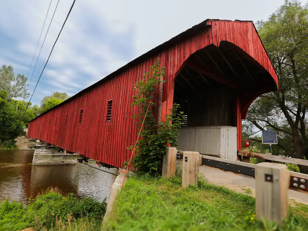
Ontario’s last covered bridge is a real piece of history tucked away in the quiet village of West Montrose. It gives visitors a chance to step back in time while being surrounded by the province’s stunning suspension bridges.
Location of the West Montrose Covered Bridge
Nestled in West Montrose, Ontario, this historic bridge crosses the Grand River. It connects Hill Street, Covered Bridge Drive, and Rivers Edge Drive. Most visitors arrive by car, with several parking spots nearby. The easiest option is Letson Park at 1232 Rivers Edge Drive, which is just a short and pleasant walk from the bridge. For quick access, there’s also a small parking area near the bridge by the convenience store.
West Montrose Covered Bridge History
Built between 1880 and 1881 by John and Benjamin Bear, it is Ontario’s only surviving covered bridge and the oldest in Canada. The bridge measures about 198 to 208 feet long and 17 feet wide. Its bright red wooden exterior with a simple gable roof makes it stand out. Originally made entirely of wood, the structure has been reinforced with concrete and steel over the years – it still looks historic. Known as “The Kissing Bridge” for its privacy, the bridge is operational for pedestrians, buggies, and small vehicles under three tons.
Points of Interest from the West Montrose Covered Bridge
From the bridge, you’ll see the Grand River and the peaceful countryside. The structure creates a perfect frame for photos during sunrise or sunset when the light is just right. Inside, the wooden interior is lit by vintage electric lamps, which were coal oil lanterns until 1950. The warm glow gives you that nostalgic feeling, making it a favourite spot for photos and history buffs alike.
Parking at the West Montrose Covered Bridge
There’s no charge to visit this historic site, which is open year-round during daylight hours. Although, donations are welcome to help preserve the covered bridge.
The neighbours are neighbourly, but they’re not to fond of tourists parking on their lawns – so, please be considerate of the properties surrounding the bridge. Your best option for parking is at the Letson Park where you can walk around, picnic and explore the area. There is no pedestrian walkway, it’s a one-lane bridge shared with cars.
Victoria Street Pedestrian Bridge

If you’re looking for a walking bridge near me, start with the famous Victoria Street Pedestrian Bridge in Elora, which blends old charm with new engineering. It links parts of the town while offering great views of the Grand River below.
Location and How To Get to the Victoria Street Pedestrian Bridge
Located in the scenic town of Elora, Ontario, this bridge crosses the Grand River, connecting downtown Elora to the south side. Visitors can park in the downtown area and walk toward the river. The bridge carries Victoria Street over the water, linking to Metcalfe Street in the heart of town. It makes for a quick walk between these busy areas.
Significant Details of the Victoria Street Pedestrian Bridge
The bridge has a long history. It was the main crossing over the Grand River for nearly 100 years, but was closed to traffic in 1969. After falling into disrepair, it was torn down in 2006. Interest in rebuilding a pedestrian crossing grew again in 2012. The current bridge features a deck that’s six meters wide and has unique circular viewing spot called belvederes in the middle. After seven years of planning and construction, it reopened to foot traffic in 2019.
What You Can See From the Victoria Street Bridge
When you walk across the bridge, you’ll see stunning views of the Grand River, the Elora Mill, and the Tooth of Time, a famous rock formation. The scene changes with every season, showing different parts of the landscape. A nearby waterfall adds extra charm. The high position of the bridge offers perfect photo opportunities of the river valley. Even though it’s a newer bridge, it stands on a site that has connected this community for many generations.
Fees and Parking for the Victoria Street Pedestrian Bridge
The best part? Crossing the Victoria Street Pedestrian Bridge is entirely free and it’s open all year. Parking can be found in downtown Elora – make sure you take the time to explore the downtown, it’s absolutely charming! Just a heads up, the weekends are extremely busy, making parking very difficult to find. Be mindful of the no parking zones, as these are regularly patrolled by by-law officers.
Black Bridge in Waterford
The Black Bridge in Waterford is an outstanding example of turning old industrial architecture into a place for fun and relaxation. It’s the main draw on the Waterford Heritage Trail and one of Ontario’s best recycled railway bridges.
Location and How To Get There
You’ll find the bridge in Waterford, Norfolk County. It’s a key part of the Trans Canada Trail system. You can reach it from several trails connecting Delhi, Port Dover, Simcoe, and Brantford, with more trails leading to Cambridge and Hamilton. Parking is easiest behind the old Co-op silos at the west end of Nichol Street, close to the trailhead.
What Makes Black Bridge So Special
Built in the late 1870s, this 166-meter-long railway bridge has been around for over 100 years. It was part of the Canadian Southern Railway until the 1980s. After the tracks were removed in the early 2000s, locals collaborated to incorporate it into the Waterford Heritage Trail. They added a deck, safety rails, and three lookout points to take in the views.
Black Bridge Landmarks
From the top of the bridge, you can see far in both directions. To the west, there’s Waterford Ponds and the tiny Miedema Bridge, a pony truss bridge, which was moved here for pedestrians in 2012. To the east, you’ll see Waterford’s charming downtown. It’s a picturesque spot to watch the sunrise or sunset, and see the many birds, animals and plants.
Black Bridge Waterford Parking and Costs
Getting to Black Bridge is free. There’s free parking behind the old Co-op silos at the west end of Nichol Street. The paved path makes it easy for strollers, wheelchairs, and all mobility devices. Throughout the year, people come here for biking, walking, photography, and birdwatching. A staircase on the south side links the upper and lower parts of the bridge, allowing visitors a chance to explore both levels and the nearby trails.
Muskoka’s McCrae Lake Bridge

Tucked away in the rough terrain of the McCrae Lake Conservation Reserve is a simple wooden bridge which crosses a beautiful waterfall. It stands out against the more modern suspension bridges found elsewhere in Ontario.
Where is the McCrae Lake Bridge Located
The bridge is located in the McCrae Lake Conservation Reserve near Georgian Bay. It crosses where the McDonald River flows from McDonald Lake into McCrae Lake, over a waterfall. Being a wilderness area, finding the bridge can be challenging for some – the signs are yellow blazes and not easliy visible. I highly suggest bringing a map.
The trail begins from the medium-sized parking lot, where you will find a ‘waterfall’ sign. At the fork off the main McCrae Lake Trail, hikers need to follow the snowmobile (ONFC) trail to reach this spot. The trail to the bridge is 2.4 km (1.5 miles) long and takes roughly 36 minutes to walk. It’s a moderate hike with some uphill sections.
Why Was the McCrae Lake Bridge Built
The bridge is a simple wooden structure that crosses the wildest part of the McDonald River Falls. It was built mainly for snowmobile traffic. Over time, people questioned whether it was a good idea to install the bridge locally. Before it was erected, many environmental groups voiced concerns over lightning strikes from thunderstorms on Georgian Bay hitting the steel beams.
The snowmobile trail starts from the south, crosses the waterfall from there, then continues north. Though it was built for utility, the bridge now serves as a landmark for hikers and paddlers exploring this quiet area.
What Can You See From the McCrae Lake Bridge
From the bridge, you can see classic Canadian Shield scenery – granite rocks, clear lakes, and tall pine trees. The wooden bridge gives a good view of the waterfall below, where water flows from McDonald Lake to McCrae Lake. Nearby, hikers can check out other views, like Eagle’s Nest.
Are There Any Costs and Parking at the McCrae Lake Bridge
It costs nothing to use the bridge, but parking can be tough. The lot fills up fast, especially in the summer months. Parking along Highway 400 or in no-parking zones will get you fined.
The best time to visit is from March to October. In winter, you can get here on a snowmobile, which was the intent of the bridge. Be sure to wear sturdy shoes – preferably hiking boots, as the trail is muddy, rocky and uneven, especially closer to the waterfall.
Belfountain Footbridge in Belfountain Village

The Belfountain Footbridge looks like something out of a fairy tale. It’s considered one of Ontario’s most picture-perfect suspension bridges.
Where is the Belfountain Footbridge in Ontario
Located in the 32-acre Belfountain Conservation Area in Caledon, this charming bridge crosses the West Credit River in the Niagara Escarpment. To visit, you need to go to the conservation area (819 Forks of the Credit Road, Caledon), which is open from late April to October. The best time to avoid the crowds is weekday mornings.
Belfountain Footbridge – A Historical Gem
Built in 1908, the bridge become a local landmark with cultural value. It stretches across a stunning waterfall, giving visitors a close-up view of the water tumbling below. The conservation area isn’t just about the bridge — it also has other historic sights, like the “belle” fountain, terraces, and the Yellowstone Cave. These features were improved through recent repairs while keeping their historical charm.
Scenic Views From the Belfountain Footbridge
The Belfountain bidge is a picture-perfect spot with breathtaking views of the cascading waterfall and the limestone cliffs that surround the river valley. A staircase by the fountain offers a different perspective of both the bridge and the waterfall. The area also has well-maintained trails, some of which are wheelchair and stroller-friendly.
Belfountain Footbridge Parking & Admission
Getting into Belfountain Conservation Area requires pre-booking online. Each reservation includes a parking spot and a two-hour time limit. If the park is not busy, you can get in without a reservation, but it’s risky — you might be turned away if it’s crowded. Unfortunately, no walk-ins are allowed. A vehicle permit is required and costs $11.30 per vehicle. There is also a general admission fee per person – the 2025 rates are as follows:
- Children under 5: FREE
- Youth (6-14 years): CAD 3.50
- Adults (15-64 years): CAD 8.00
- Seniors (65+ years): CAD 6.50
Just an FYI – your paid reservation gives you free access to all Credit Valley Conservation Parks – Terra Cotta Conservation, Island Lake Conservation Park, Ken Whillans Conservation Area, and Upper Credit Conservation Area.
Peterborough County’s Doube’s Trestle Bridge – NOW REOPENED!

Doube’s Trestle Bridge, also known as Orange Corners’ Trestle Bridge, was once part of a railway line but is now a popular stop along the Great Trail (aka Trans-Canada Trail).
How To Get to the Doube’s Trestle Bridge
Located west of Peterborough near Omemee, the bridge crosses Buttermilk Creek on the Greenway Trail section of the Kawartha Trans-Canada Trail. On the west side of Orange Corners Road is roadside parking close to the trailhead. Hikers, runners, cyclists, and snowmobilers can reach the bridge by walking about 2 kilometres from either end on the smooth, flat trail.
Doube’s Trestle Bridge History
Its most significant role was linking Peterborough to Lindsay, making it a key connection point. The bridge towers 21 meters (approx. 70 feet) above the creek and spreads out 174 meters (around 572 feet) across the Buttermilk Valley.
Built in the late 1800s, the bridge was later converted from wood to a steel bridge. In 2020, the bridge’s decking was changed to composite lumber. Unfortunately, 5 years later, a section of the bridge caught on fire, which has been repaired this year.
What Can You See From the Doube’s Trestle Bridge
From up high, you’ll experience sweeping views of farms and tree canopies in Buttermilk Valley. In spring, you can watch the creek rush below, while in the summer, the green canopies are right at eye level. During autumn, the scene looks like a countryside painting with its bright leaves and rolling hills.
If you’re a bird watcher there is plenty opportunity to spot different species that live in the forest around the bridge. FYI – For fans of Monk, Mr. Monk’s Last Case: A Monk Movie was filmed here.
Cost & Parking at Doube’s Trestle Bridge
Access to Doube’s Trestle railway suspension bridge is free all year, at all hours – as is parking near the trailheads. There is no parking near the trailheads from November to April. Winter visits depend on snow and trail upkeep. For dog walkers, make sure you keep it on a leash while crossing the bridge.
Comparison Table
| Bridge Name | Length | Height | Location | Year Built/Opened | Access Fee | Notable Features |
|---|---|---|---|---|---|---|
| Ranney Gorge | 92m (301ft) | 9-10.6m (30-35ft) | Campbellford | 2004 | Free from west side; Park fees apply from east | Can support 75,000 pounds; Part of The Great Trail |
| Scenic Caves | 128m (420ft) | 25m (82ft) | Blue Mountains | 2003 | CAD 35.00/adult | Southern Ontario’s longest suspension footbridge; 360° panoramic views |
| White River | 30m (98.4ft) | 23m (75.4ft) | Pukaskwa National Park | Mid-20th century | National Park fees apply | Crosses Chigamiwinigum Falls; 18km round-trip hike required |
| Eagle Canyon | 182.8m (600ft) | 46.3m (152ft) | Dorion Township | 2018 | CAD 23.00/adult | Canada’s longest foot suspension bridge; Includes a second 300ft bridge |
| William E. Small | 156m (512ft) | 27m (90ft) | French River Provincial Park | 2005 | Provincial Park fees apply | World’s largest snowmobile bridge; Can support 100+ snowmobiles |
| Menesetung | 228.6m (750ft) | 60m | Goderich | 1906-1907 | Free | Former railway bridge; Seven spans of 104ft each |
| West Montrose | 60-63m (198-208ft) | 19.8m (65ft) | West Montrose | 1880-1881 | Free | Ontario’s last remaining covered bridge; Known as “Kissing Bridge” |
| Victoria Street | 90m | Not mentioned | Elora | 2019 | Free | Features: circular viewing platforms; Spans Grand River |
| Black Bridge | 166m | Not mentioned | Waterford | 1916 | Free | Former railway bridge; Three overlook points |
| McCrae Lake | Not mentioned | Not mentioned | McCrae Lake Conservation Reserve | 2001 | Free | Wooden bridge over waterfall; Limited parking |
| Belfountain | Not mentioned | Not mentioned | Caledon | 1908 | Reservation required | Spans West Credit River; Historical heritage feature |
| Doube’s Trestle | 174m (572ft) | 21m (70ft) | Near Omemee | Late 1800s | Free | Former railway trestle; Part of the Trans Canada Trail |
Ontario’s Suspension Bridge FAQs
The Eagle Canyon Suspension Bridge holds the title of Canada’slongest foot suspension bridge, stretching an impressive 600 feet across the canyon and hanging 152 feet above the canyon floor.
The Scenic Caves Suspension Bridge in the Blue Mountains provides spectacular 360-degree panoramic views spanning approximately 10,000 square kilometres, including Georgian Bay and surrounding landscapes.
Yes, the West Montrose Covered Bridge, which was built in 1880-1881, is Ontario’s last remaining covered bridge. It’s affectionately known as the “Kissing Bridge” due to the privacy it once afforded travellers.
The William E. Small Suspension Bridge in French River Provincial Park is the world’s largest snowmobile bridge. It can support over 100 snowmobiles simultaneously and serves as a vital connection for winter trails.
The White River Suspension Bridge in Pukaskwa National Park offers a thrilling experience for adventurous hikers. It requires an 18-kilometre round-trip hike through rugged terrain to reach the bridge, which spans the dramatic Chigamiwinigum Falls.
Concluding Suspension Bridges in Ontario
Not every suspension hangs 700 ft in the air, which is what makes Ontario’s suspension bridges so captivating and unique. These bridges are an invitation for you to explore them, take in the panoramic views and appreciate their natural surroundings.
Start with an old favourite like the West Montrose Covered Bridge, built in 1880, or if you’re feeling brave, tackle the Eagle Canyon Bridge, which towers 600 feet above the canyon floor.
Every bridge on this list is unique. Some require effort, like the White River Suspension Bridge, which involves an 18-kilometre round-trip hike. Others are more easygoing, offering quick access and great views, like the Menesetung Bridge over the Maitland River valley. No matter which ones you visit, each one has something special to offer, especially as seasons change. Fall adds vibrant colours that make for perfect photos, while winter transforms many into snowy scenes. The William E. Small Bridge becomes popular with snowmobilers when it’s cold enough.
Even if these spots seem far apart, planning a road trip to visit several bridges can make for an unforgettable trip around Ontario.
👉 After checking out these bridges, I’d love to hear your stories. Share your favourite suspension bridge in the comments below! The next time you’re looking for things to do in Ontario, Canada, remember these bridges are waiting. Each one promises a fun crossing and memorable scenery!
Bookmark this post on Pinterest for future reference!


The views are stunning! I would love to visit Ontario. Thank you for sharing the comparison table it is helpful to compare.
Thank you! Ontario is definitely worth the trip – so much to see and do. We also have some stunning waterfalls!
Thanks for all the work you put into this, it’s a great resource 😁
Awe, thanks so much for your comment!!!
These are beautiful! I would probably cry though because I’m afraid of heights.
Oh no, my hubby is afraid of heights too, but he managed to walk 1/3 of the bridge before turning around. Start small and work your way up – the views are stunning no matter the height. 🙂
What an incredible guide to Ontario’s suspension bridges! I love how you’ve captured both the thrill and beauty of these structures. Your description of the Ranney Gorge bridge being built by military engineers as a training project is fascinating! What a cool piece of history!
The suspension bridges mentioned seem absolutely beautiful! Any tips for anyone who has never been walking on one but wants to and needs to face their fears?!
It’s the tought of crossing one that gets the stomach turning and the adrenaline pumping. My hubby is afraid of heights and refuses to go on, but I managed to to get him to step foot at least a third of the way. The key is not to look down, pick a point and focus on that. Hold on to the rails (don’t knuckle grip) or onto a loved one for support and walk slowly. When you feel the bridge sway, take a deep breath and keep focusing on the visuals – don’t let the mind wander off to negative thoughts and DON’T look down – unless you conquered your fear. I hope these tips help! Happy crossing – you’ve got this! 🙂
Nice photos
Thank you so much! Appreciate the comment!
Wow! Cool! Thanks for sharing!
Nice
Thank you!
[…] 12 Most Beautiful Suspension Bridges in Ontario You Need to See in 2025 […]
This sounds like such a fun adventure! I love that mix of excitement and a little bit of fear — it makes the experience even more memorable. I’d probably be like your husband at first, gripping those poles tight, but the views must make it all worth it! The Ranney Gorge Suspension Bridge is definitely going on my Ontario must-see list!
The views from the poles are great, but they’re even better from the bridge! I always suggest taking a deep breaths, pick a focal point and don’t look down. Once you’re centred and the fear passes, then you can take a quick peak down. Have fun exploring our spectacular bridges!
I had no idea there were so many suspension bridges in Ontario. We’ve been to a few of them. I really regret not seeing the Eagle Canyon Suspension Bridge when we took a road trip across Northern Ontario. Especially since it’s so close to Ouimet Canyon.
Same here! It’s not until you go through your photos that you realize that there are so many Ontario suspension bridges. Eagle Canyon was one of our favourites. Hopefully, you’ll get the chance to take in the stunning views some day soon.